
Explore Our Products
Surveying & Engineering
Mobile
Mapping
Hydrographic Surveying
Surveying & Engineering
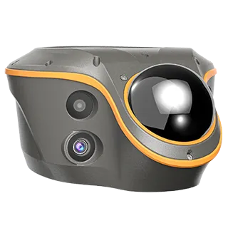
CHCNAV ViLi i100
Versatile Visual-LiDAR RTK
Once Right, Always Right — Confident and Consistent Accuracy in Obstruction.
SFix 2.0 — Reliable 0.16 US ft Accuracy within 66 US ft in GNSS-Denied Areas.
Real-Time 3D Point Cloud Earthwork Calculation: Accurate, Fast & Safe.
Vi-LiDAR: Take a Photo, Capture Points to Survey, No Need to Aim or Stay Rock-Steady.
All-in-One Flagship GNSS Receiver: With All Conventional Features Involved.
HIGHLIGHTS
The ViLi i100 is CHCNAV's flagship Visual-LiDAR GNSS RTK receiver for next-generation of high-precision surveying. With advanced GNSS satellite signal filtering, multi-sensor fusion, SFix 2.0 algorithms, and integrated Vi-LiDAR, it ensures consistent centimeter-level accuracy.
Designed for complex environments, the ViLi i100 enables precise data collection across diverse terrains, enabling users to work confidently even beyond the traditional limits of GNSS.
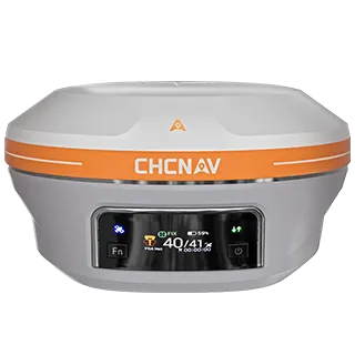
CHCNAV i93
Versatile IMU-RTK with Vision
Visual Surveying — Dual cameras extract survey-grade 3D coordinates improving measurement efficiency.
Visual Stakeout — Guidance by a clear, eye-catching directional information.
3D Modeling — Dynamic panoramic video capture.
Auto-IMU Technology — 200 Hz Auto-IMU for automatic pole tilt compensation.
HIGHLIGHTS
The i93 GNSS receiver is an extremely versatile RTK that integrates the latest GNSS, IMU, and premium dual-camera technologies for a more compelling user experience. The visual stakeout streamlines construction layout with intuitive AR visual guidance, boosting on-site efficiency. Visual survey leverages video-photogrammetry to capture precise data from hard-to-reach, signal-obstructed, and hazardous areas. Seamlessly compatible with leading 3D modeling software, it perfectly complements aerial oblique imagery surveys for comprehensive 3D modeling. Enhanced by iStar RTK algorithm and multi-band GNSS, it delivers reliable high-accuracy positioning in tough conditions. Auto-IMU with automatic initialization eliminates manual setup, simplifying field operations. The i93 is the ideal solution for completing tasks faster, more accurately, and more efficiently.
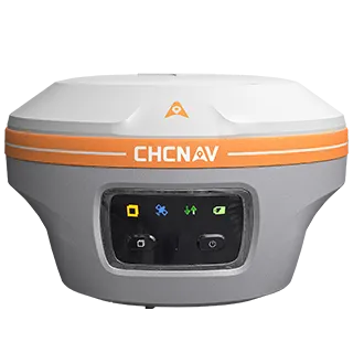
CHCNAV i85
Pocket-Sized Laser IMU-RTK GNSS
LASER SURVEY — Laser rangefinder captures survey-grade 3D coordinates from hard-to-reach points.
EXTREME GNSS PERFORMANCE — CHCNAV iStar2.0 GNSS engine and advanced GNSS module, 96% fix reliability with 20% improved data quality.
VISUAL NAVIGATION AND STAKEOUT — GNSS, IMU, and visual sensor fusion, powered by a 1.5 GHz processor with adaptative Wi-Fi VPT™ technology.
AUTO-IMU — 200 Hz AUTO-IMU with no manual initialization. Maintains 1.18 in accuracy over a 60° tilt range, reducing field time by up to 30%.
HIGHLIGHTS
The CHCNAV i85 is a compact, high-performance GNSS solution for daily land surveying. Featuring a 1408-channel GNSS module, advanced IMU, integrated dual cameras, and laser rangefinder, it delivers reliable positioning in challenging environments, even under high solar activity. Weighing 1.76 lb with an IP68 rating and 20-hour battery life, the i85 ensures efficient, dependable RTK performance in the field.
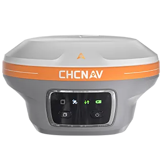
CHCNAV i89
Pocket-Sized Visual IMU-RTK GNSS
Superior GNSS
Visual Survey
Visual Stakeout
Auto-IMU
HIGHLIGHTS
The i89 is a compact visual GNSS receiver with a 1408-channel module, boosting RTK availability in challenging environments. Its CHCNAV iStar2.0 software uses advanced ionospheric modeling to deliver high-integrity RTK fix rates in solar-active regions. Visual surveying extracts accurate 3D coordinates from video, simplifying measurements in signal-obstructed, hard-to-reach or dangerous areas. Integrated AR visual navigation and stakeout improves efficiency by 50%. AUTO-IMU eliminates manual initialization to streamline field work. With 16.5 hours of battery life and a 1.65 lb lightweight design, it ensures optimal daily survey productivity.
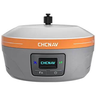
CHCNAV iBase
Integrated GNSS Base for Optimal Ease of Use
13 H+ Endurance
25 KM Coverage
Ultra Base
Premium GNSS
HIGHLIGHTS
The iBase GNSS receiver offers a streamlined solution as a GNSS base station designed to meet surveyor's needs. Its performance rivals that of a standard external UHF radio modem without the bulk of external batteries, cables, radios, and antennas. With a 5-watt radio module, it provides GNSS RTK coverage up to 15.53 miles under optimal conditions. Its real-time UHF interference self-checking capability allows operators to select the best frequency channel, increasing ease of use and efficiency. In addition, iBase's integrated AUTO-IMU enhances its functionality as a GNSS rover.