
 Image 1 of 1
Pocket2 PRO - Seamless Real-time Spatial Scanner
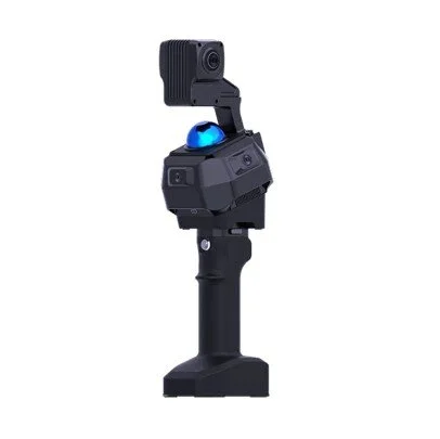
Pocket2 Pro is a professional handheld 3D environment acquisition and intelligent processing device designed for high-quality spatial reconstruction, panoramic documentation, and 3D Gaussian Splatting workflows.
Combining high-performance LiDAR, three global-shutter RGB cameras, dual high-resolution top-mounted cameras, and Manifold Tech’s proprietary MindSLAM® algorithm, Pocket2 Pro captures accurate true-color dense point clouds, high-resolution panoramic images and videos, and detailed photos in a single field operation.
More than a SLAM scanner, Pocket2 Pro is built to create visual, measurable, and reusable digital environments. Users can scan once and generate multiple deliverables, including colored point clouds, panoramic walk-through records, detail image documentation, mesh models, and 3DGS-ready datasets for immersive visualization, digital twin creation, robotics simulation, cultural heritage recording, AEC documentation, and industrial inspection.
Powered by the MindCloud software ecosystem, Pocket2 Pro connects field capture with structured post-processing and cloud collaboration. Data can be uploaded, processed, viewed, shared, and exported through MindCloud Studio, MindCloud Go, MindCloud Render, and MindCloudX.AI, enabling a streamlined workflow from real-world capture to high-quality 3D results.
CORE FUNCTIONS
Multi-Modal 3D Capture
Pocket2 Pro integrates LiDAR, global-shutter RGB cameras, high-resolution top-mounted cameras, and IMU data to capture geometry, color, panoramic imagery, videos, and detailed photos in one on-site workflow.
True-Color Dense Point Clouds
The device supports real-time point cloud scanning and visualization, helping operators review data completeness on site and reduce occlusion, sparse areas, and rework.
3DGS-Ready Data Pipeline
When paired with MindCloud Render and MindCloudX.AI, Pocket2 Pro enables a practical field-to-3DGS workflow for immersive scene visualization, digital twins, and reusable spatial assets.
High-Resolution Panoramic Documentation
Panoramic image capture preserves visual context, site conditions, and inspection evidence, making projects easier to review, share, and communicate with teams, clients, and stakeholders.
Cloud Collaboration and Multi-Device Delivery
Captured data can be uploaded, processed, viewed, shared, and exported through the MindCloud software suite, supporting team-level collaboration and faster project delivery.
Robotic Collaboration Ecosystem
Pocket2 Pro can also serve as a spatial data entry point for robotic workflows, supporting environment mapping, relocalization, simulation, and integration with the broader Manifold Tech ecosystem.
TYPICAL APPLICATION SCENARIOS
3DGS and Immersive Digital Twins
Capture real-world scenes once and convert them into 3DGS-ready datasets for immersive visualization, remote presentation, spatial computing, and digital twin applications.
Panoramic Site Documentation and Remote Review
Use high-resolution panoramic images, videos, and detail photos to document visual conditions, site context, progress, and inspection evidence for remote review and stakeholder communication.
AEC, Interior Measurement, and Renovation Planning
Generate true-color point clouds, mesh models, and measurable spatial data to support interior measurement, renovation planning, construction documentation, and reporting.
Digital Asset Capture and Cultural Heritage Recording
Capture facades, textures, structures, spatial context, and visual details with high fidelity for cultural heritage documentation, virtual exhibition, restoration planning, and digital reconstruction.
Industrial Inspection and Asset Management
Document industrial facilities, equipment areas, data centers, warehouses, energy sites, and other complex spaces with measurable 3D data and visual records that support inspection, maintenance, and asset management.
Robotic Deployment, Navigation Mapping, and Simulation
Quickly scan robotic work environments and generate spatial data for navigation maps, relocalization, Scan-to-Sim workflows, and robot deployment when integrated with Manifold Tech robotic modules and software.
Technical Specifications
Dimensions - 4.5 × 4.4 × 4.7 in (115 × 113 × 120 mm)
Device Weight - 2.12 lbs(962 g)
Battery Handle Weight - 1.1 lbs(485 g)
Operating Temperature - 14°F to 104°F (-10°C to 40°C)
Data Interface - USB 3.0
Storage - Built-in SSD, 1 TB
Battery Capacity - 4000 mAh
Battery Life (Single Battery) - Up to 120 minutes
Point Cloud Accuracy - Better than 0.4 in (≤ 1 cm)
Camera System - 3 × 2 MP Global Shutter RGB Cameras PLUS 2 × 12 MP High-Resolution Top-Mounted Cameras
Laser Wavelength - 905 nm
Laser Channels - 40 channels
Point Rate - 200,000 points/sec
Measurement Range - 131 ft @ 10% reflectivity / 230 ft @ 80% reflectivity (40 m / 70 m)
Global Positioning Accuracy - Better than 2 in (≤ 5 cm), typical ~1.2 in (≈ 3 cm)
MindCloud Studio
Output Formats: .las, .laz, .fbx, .e57, .pcd, .ply, .obj
Supports USD export (NVIDIA Omniverse) for robotic simulation and training
Generate grayscale and true-color mesh models
Support external control point import
MindCloud Go(APP)
Annotation mode with label import and quick review workflow
One-tap switching between intensity and true-color rendering modes
One-click cloud upload for LAS and colored point cloud data
Pocket2 Pro is a professional handheld 3D environment acquisition and intelligent processing device designed for high-quality spatial reconstruction, panoramic documentation, and 3D Gaussian Splatting workflows.
Combining high-performance LiDAR, three global-shutter RGB cameras, dual high-resolution top-mounted cameras, and Manifold Tech’s proprietary MindSLAM® algorithm, Pocket2 Pro captures accurate true-color dense point clouds, high-resolution panoramic images and videos, and detailed photos in a single field operation.
More than a SLAM scanner, Pocket2 Pro is built to create visual, measurable, and reusable digital environments. Users can scan once and generate multiple deliverables, including colored point clouds, panoramic walk-through records, detail image documentation, mesh models, and 3DGS-ready datasets for immersive visualization, digital twin creation, robotics simulation, cultural heritage recording, AEC documentation, and industrial inspection.
Powered by the MindCloud software ecosystem, Pocket2 Pro connects field capture with structured post-processing and cloud collaboration. Data can be uploaded, processed, viewed, shared, and exported through MindCloud Studio, MindCloud Go, MindCloud Render, and MindCloudX.AI, enabling a streamlined workflow from real-world capture to high-quality 3D results.
CORE FUNCTIONS
Multi-Modal 3D Capture
Pocket2 Pro integrates LiDAR, global-shutter RGB cameras, high-resolution top-mounted cameras, and IMU data to capture geometry, color, panoramic imagery, videos, and detailed photos in one on-site workflow.
True-Color Dense Point Clouds
The device supports real-time point cloud scanning and visualization, helping operators review data completeness on site and reduce occlusion, sparse areas, and rework.
3DGS-Ready Data Pipeline
When paired with MindCloud Render and MindCloudX.AI, Pocket2 Pro enables a practical field-to-3DGS workflow for immersive scene visualization, digital twins, and reusable spatial assets.
High-Resolution Panoramic Documentation
Panoramic image capture preserves visual context, site conditions, and inspection evidence, making projects easier to review, share, and communicate with teams, clients, and stakeholders.
Cloud Collaboration and Multi-Device Delivery
Captured data can be uploaded, processed, viewed, shared, and exported through the MindCloud software suite, supporting team-level collaboration and faster project delivery.
Robotic Collaboration Ecosystem
Pocket2 Pro can also serve as a spatial data entry point for robotic workflows, supporting environment mapping, relocalization, simulation, and integration with the broader Manifold Tech ecosystem.
TYPICAL APPLICATION SCENARIOS
3DGS and Immersive Digital Twins
Capture real-world scenes once and convert them into 3DGS-ready datasets for immersive visualization, remote presentation, spatial computing, and digital twin applications.
Panoramic Site Documentation and Remote Review
Use high-resolution panoramic images, videos, and detail photos to document visual conditions, site context, progress, and inspection evidence for remote review and stakeholder communication.
AEC, Interior Measurement, and Renovation Planning
Generate true-color point clouds, mesh models, and measurable spatial data to support interior measurement, renovation planning, construction documentation, and reporting.
Digital Asset Capture and Cultural Heritage Recording
Capture facades, textures, structures, spatial context, and visual details with high fidelity for cultural heritage documentation, virtual exhibition, restoration planning, and digital reconstruction.
Industrial Inspection and Asset Management
Document industrial facilities, equipment areas, data centers, warehouses, energy sites, and other complex spaces with measurable 3D data and visual records that support inspection, maintenance, and asset management.
Robotic Deployment, Navigation Mapping, and Simulation
Quickly scan robotic work environments and generate spatial data for navigation maps, relocalization, Scan-to-Sim workflows, and robot deployment when integrated with Manifold Tech robotic modules and software.
Technical Specifications
Dimensions - 4.5 × 4.4 × 4.7 in (115 × 113 × 120 mm)
Device Weight - 2.12 lbs(962 g)
Battery Handle Weight - 1.1 lbs(485 g)
Operating Temperature - 14°F to 104°F (-10°C to 40°C)
Data Interface - USB 3.0
Storage - Built-in SSD, 1 TB
Battery Capacity - 4000 mAh
Battery Life (Single Battery) - Up to 120 minutes
Point Cloud Accuracy - Better than 0.4 in (≤ 1 cm)
Camera System - 3 × 2 MP Global Shutter RGB Cameras PLUS 2 × 12 MP High-Resolution Top-Mounted Cameras
Laser Wavelength - 905 nm
Laser Channels - 40 channels
Point Rate - 200,000 points/sec
Measurement Range - 131 ft @ 10% reflectivity / 230 ft @ 80% reflectivity (40 m / 70 m)
Global Positioning Accuracy - Better than 2 in (≤ 5 cm), typical ~1.2 in (≈ 3 cm)
MindCloud Studio
Output Formats: .las, .laz, .fbx, .e57, .pcd, .ply, .obj
Supports USD export (NVIDIA Omniverse) for robotic simulation and training
Generate grayscale and true-color mesh models
Support external control point import
MindCloud Go(APP)
Annotation mode with label import and quick review workflow
One-tap switching between intensity and true-color rendering modes
One-click cloud upload for LAS and colored point cloud data