
Free US shipping on CHCNAV GNSS receivers, iBase and RS7. Shipping for other products is charged separately.
How to choose a GNSS receiver
Buying guidance
Choose a GNSS setup around the work your crew needs to finish: the points you measure, the places you work and the files you hand over. We recommend comparing the complete field-to-office workflow before choosing a receiver by a headline specification.
For straightforward point collection and visual stakeout, start with the i89 and i93. Bring the i85 into the comparison when aimed, contactless point measurement matters. Evaluate the ViLi i100 when you need a combined GNSS, visual and LiDAR workflow around obstructions. The right choice depends on whether those extra capture methods solve a recurring job for your crew.
Start with the deliverable
Write down the required horizontal and vertical tolerances, coordinate system, units, geoid or vertical reference, feature coding and final file type. Identify who will check and accept the work. A topographic point file, a construction layout task and a point-cloud volume workflow need different demonstrations.
Then describe the hard part of a normal site: tree cover, buildings, traffic, a steep bank, weak cellular coverage or points you cannot occupy. Bring one representative job file and a few independently checked points to the comparison. Keep a conventional measurement method available for places where the proposed workflow does not meet the requirement.
Compare the four receivers by the job
On a small screen, swipe the table or focus it and use the arrow keys. Row labels stay visible.
| Model | Capture method | When we would shortlist it | What to prove in a demo |
|---|---|---|---|
CHCNAV i89 | GNSS, tilt compensation and dual-camera visual surveying | Daily rover work where compact size and visual point capture are useful | Collect normal points, capture an inaccessible feature and export both into your office workflow. |
CHCNAV i93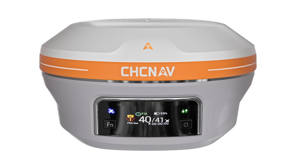 | GNSS, tilt compensation and dual-camera visual surveying; integrated 4G | A crew that values longer operating time, integrated connectivity or using the receiver in rover and base roles | Run the intended correction connection and visual workflow with the exact supplied version. |
CHCNAV i85 | GNSS with an aimed laser rangefinder and cameras | Repeated discrete points where a pole cannot safely reach and the target can be aimed at | Check actual target surfaces, distance, lighting and laser measurement residuals. |
CHCNAV ViLi i100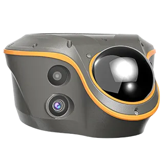 | GNSS, vision and LiDAR with SFix positioning | Obstructed-site work, batch contactless points or on-site point-cloud tasks | Compare checked points through an obstruction transition and inspect the final point or cloud output. |
Useful specifications with their conditions
On a small screen, swipe the table or focus it and use the arrow keys. Row labels stay visible.
| Published specification | i89 | i93 | i85 | ViLi i100 |
|---|---|---|---|---|
| Receiver weight | 750 g | 1.15 kg | 800 g | 1.39 kg |
| RTK rover runtime without camera use | Up to 16.5 h | Up to 34 h | Up to 20 h | Typical 22 h |
| Higher-power capture runtime | Visual: up to 9.5 h | Visual: up to 24 h | Laser or visual: up to 15 h | SFix / Vi-LiDAR / scan: up to 5 h |
| Built-in UHF radio | Transmit / receive | Transmit / receive | Transmit / receive | Receive only |
| Ingress protection | IP68 | IP68 | IP68 | IP67 |
| Contactless survey reference | Typical 2–4 cm at 2–15 m | Typical 2–4 cm at 2–15 m | Rapid laser: 3 cm at 5 m; 5 cm at 10 m | Vi-LiDAR: typical ±5 cm at 15 m with GNSS |
These are manufacturer figures for the cited revisions, not guaranteed results on a customer site. Battery life depends on operating mode and conditions. Visual, laser and Vi-LiDAR figures describe different measurement methods and are not a controlled head-to-head accuracy test. The four datasheets list conventional RTK accuracy as 8 mm + 1 ppm horizontal and 15 mm + 1 ppm vertical RMS under favorable GNSS conditions.
The current i85 literature advertises laser range up to 150 m under favorable conditions, including nighttime and highly reflective targets. That is not a 150 m survey-accuracy promise. Its green laser is Class 3R; follow the exact model manual and site safety procedure.
For ViLi i100, the SFix specification is ±5 cm (2 sigma) at a 20 m radius without GNSS, with the datasheet noting increasing error beyond that distance. Run an obstruction test with independent checks, and retain a fallback instrument for work outside the validated conditions.
Choose how corrections will reach the rover
Network RTK: useful when an appropriate correction service and reliable data connection cover your sites. Confirm the mountpoint, correction format, account access and the controller or receiver connection.
Local base and rover: useful when you need your own correction source or cannot rely on cellular coverage. Budget for the base setup, known coordinates, radio configuration, power and field checks. Demonstrate the actual base-to-rover link.
Satellite-delivered corrections: evaluate the exact receiver, supported region, service eligibility, convergence and expected accuracy. PointSky appears in current i85 and i93 materials, but the quoted GLG version and entitlement must be established.
Radio compatibility, field-controller compatibility and file compatibility are separate checks. A receiver accepting a correction format does not prove that every existing radio, controller or office application will work with it.
What belongs in a complete setup quote
Ask for an itemized receiver and firmware version; controller or tablet; field software and activated functions; pole and mounts; chargers, cables and spare-power plan; correction source; any base hardware; office processing and export tools; and the agreed setup or training scope. Separate one-time costs from renewals, subscriptions and optional processing.
LandStar supports CAD-based survey workflows and lists formats including DWG, DXF and SHP. Verify the actual import, coding and export path with your own project. A supported format name does not guarantee that every object or attribute transfers exactly as your office expects.
Frequently asked questions
Is the i93 automatically more accurate than the i89
No. Their cited conventional RTK specifications are the same. The buying differences include size, runtime, connectivity, version and the way the crew uses the system. Compare results and total working time on the same task.
Can visual or laser surveying replace occupying every point
It can help with suitable inaccessible points. The measurement method, target visibility and checking procedure still need to meet the job requirement. Use a demo to determine which points you can reliably collect and which need another method.
Can we keep our existing controller or base
Possibly. Provide the exact model, firmware, radio protocol, correction format and field software. We recommend testing the intended combination and a round-trip office file before ordering.
Should we buy a base with every rover
Choose the correction workflow first. An appropriate network service may remove the need for a local base on some jobs; a dedicated base may be useful on others. Compare coverage, site control, setup time and recurring costs.
Next step
Send us the work you do, your current equipment, typical site conditions and one example deliverable. Request a complete setup quote, or use our equipment demo checklist to define a fair comparison.
Related buying guides
- How to choose a handheld LiDAR scanner
- Pocket2 and Pocket2 Pro buying comparison
- Survey equipment demo checklist
Before selecting a configuration
- Record the exact supplied model, part numbers, hardware and firmware versions.
- Check correction-service eligibility, regional coverage, accuracy, convergence and current service terms.
- Match capture hardware, control requirements, software modules and file outputs to your workflow.
- Compare ready-to-scan weights and verify accessory compatibility for the supplied revision.
- Review current prices, availability, shipping, applicable taxes, included items and license terms before ordering.
- Agree any demonstration, training, support and sample-data permissions as part of your quote.
Sources
Sources were checked October 5, 2026. Datasheet revisions are recorded where visible. Product pages can change, so the final quote should identify the specification for the supplied version. Manual links below lead to official support or download pages; select the exact model and current document there.
Manual navigation note: Manifold’s download site uses product selection. Choose Pocket2 or Pocket2 Pro and then Documentation Manual; the product query URL may open the general software panel. Downloading an installer does not establish a software entitlement.
- S1 CHCNAV i89 product page
- S2 CHCNAV i93 product page
- S3 CHCNAV i85 product page
- S4 CHCNAV ViLi i100 product page
- S5 i89 English datasheet revision March 2025
- S6 i93 English datasheet revision August 2026
- S7 i85 English datasheet revision June 2026
- S8 ViLi i100 English datasheet revision August 2025
- S9 Manifold Pocket2 product and specifications
- S10 Manifold MindPalace Pocket2 Pro product and specifications
- S11 CHCNAV RS7 product page
- S12 RS7 English datasheet revision January 2026
- S13 CHCNAV LandStar product page
- S14 Manifold download center and Studio license notice
- S15 CHCNAV CoPre product page
- S16 CHCNAV CoCloud product page and pricing FAQ
- M1 i89 official user manual landing page
- M2 i93 official user manual landing page
- M3 i85 official user manual landing page
- M4 ViLi i100 official user manual landing page
- M5 RS7 official user manual landing page
- M6 Manifold product downloads and manuals