
 Image 1 of 1
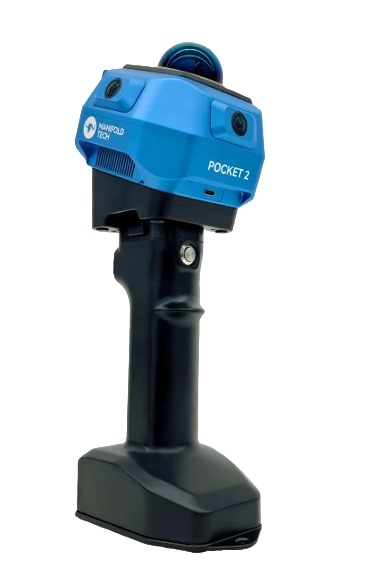
DEMO Pocket2 - Seamless Real-time Spatial Scanner (256gb) DEMO
Demo unit. Comes with a 90-day warranty.
Capture 3D spaces while you move.
MindPalace Pocket2 brings high-precision depth sensing, real-time point cloud reconstruction, wireless data transmission and cloud collaboration together in one handheld device for real-time spatial scanning.
Manifold Tech's MindSLAM® algorithm keeps Pocket2's sensors synchronized and fuses their data at the pixel level, so you can produce professional-grade 3D scans without specialist reconstruction expertise. Built-in templates for different jobs and one-click cloud upload help you turn a scan into standardized deliverables for interior measurement and modeling, accident reconstruction, forestry surveys, digital asset capture, stockpile and volume calculations, and robot deployment.
Whether for individual users, collaborative teams, or industry-scale projects, Pocket2 simplifies complex workflows into a single, standardized process, enabling faster execution and higher efficiency
CORE FUNCTIONS
Multi-Modal Sensor Fusion
No training required – simply power on and scan. Pocket2 combines a global shutter camera, LiDAR, and IMU with the MindSLAM® algorithm to deliver stable odometry and real-time, high-precision colored point clouds, even in complex or dynamic environments.
Real-Time Point Cloud & Measurement
Pocket2 supports a true "scan and see" workflow, allowing instant detail refinement. This reduces sparse areas and occlusion blind spots while ensuring data completeness, accuracy, and usability for measurement and modeling.
One-Tap Cloud Sync & Multi-Device Collaboration
It connects seamlessly with your app and the cloud, automatically generating high-quality, lightweight 3D files. Data can be viewed, edited, and exported across devices, enabling real-time collaboration and accelerated project delivery.
Robotic Collaboration Ecosystem
More than a scanner! It is the entry point to the Manifold Tech ecosystem. Through deep integration with the Odin module, it feeds precise 3D environmental data into robotic systems, enabling advanced perception and autonomous decision-making.
TYPICAL APPLICATION SCENARIOS
Interior Measurement & Renovation Planning
With one-click cloud upload after capture. Pocket2 enables fast generation of CAD drawings and dimensioned files, providing solid data support and clear visualization for design, construction, and reporting.
Forestry Survey & Ecological Sampling
For forestry applications, Pocket2 labels tree species and locations while generating high-density forest point clouds. It supports exporting structured data such as species type and spatial distribution, making it easy to produce sampling files and statistical reports.
Digital Asset Capture & Cultural Heritage Recording
For cultural heritage and historical architecture, Pocket2 captures facades, textures, and structural details with high fidelity. The data can be imported into Blender, Unreal, or BIM platforms for modeling, restoration, and digital reconstruction.
Robotic Deployment & Navigation Mapping
Use Pocket2 to quickly scan robotic work environments and generate high-precision navigation maps with one click. When combined with the Odin module, it enables rapid robot deployment, accurate relocalization, and dynamic obstacle avoidance.
Technical Specifications
Dimensions - 4.5 × 4.4 × 4.7 in (115 × 113 × 120 mm)
Operating Temperature - 14°F to 104°F (-10°C to 40°C)
Data Interface - USB 3.0
Storage - Built-in SSD, 256 GB
Battery Capacity - 4000 mAh
Battery Life (Single Battery) - Up to 120 minutes
Point Cloud Accuracy - Better than 0.4 in (≤ 1 cm)
Camera System - 3 × 2 MP Global Shutter RGB Cameras
Laser Wavelength - 905 nm
Laser Channels - 40 channels
Point Rate - 200,000 points/sec
Measurement Range - 131 ft @ 10% reflectivity / 230 ft @ 80% reflectivity (40 m / 70 m)
Global Positioning Accuracy - Better than 2 in (≤ 5 cm), typical ~1.2 in (≈ 3 cm)
MindCloud Studio
Output Formats: .las, .laz, .fbx, .e57, .pcd, .ply, .obj
Supports USD export (NVIDIA Omniverse) for robotic simulation and training
Generate grayscale and true-color mesh models
Support external control point import
MindCloud Go(APP)
Annotation mode with label import and quick review workflow
One-tap switching between intensity and true-color rendering modes
One-click cloud upload for LAS and colored point cloud data
Included
Contact GLG for the exact supplied demo configuration and condition before ordering.
Required separately
Computer and software requirements depend on your processing workflow.
Optional
Choose compatible accessories and software for your workflow.
Demo unit. Comes with a 90-day warranty.
Capture 3D spaces while you move.
MindPalace Pocket2 brings high-precision depth sensing, real-time point cloud reconstruction, wireless data transmission and cloud collaboration together in one handheld device for real-time spatial scanning.
Manifold Tech's MindSLAM® algorithm keeps Pocket2's sensors synchronized and fuses their data at the pixel level, so you can produce professional-grade 3D scans without specialist reconstruction expertise. Built-in templates for different jobs and one-click cloud upload help you turn a scan into standardized deliverables for interior measurement and modeling, accident reconstruction, forestry surveys, digital asset capture, stockpile and volume calculations, and robot deployment.
Whether for individual users, collaborative teams, or industry-scale projects, Pocket2 simplifies complex workflows into a single, standardized process, enabling faster execution and higher efficiency
CORE FUNCTIONS
Multi-Modal Sensor Fusion
No training required – simply power on and scan. Pocket2 combines a global shutter camera, LiDAR, and IMU with the MindSLAM® algorithm to deliver stable odometry and real-time, high-precision colored point clouds, even in complex or dynamic environments.
Real-Time Point Cloud & Measurement
Pocket2 supports a true "scan and see" workflow, allowing instant detail refinement. This reduces sparse areas and occlusion blind spots while ensuring data completeness, accuracy, and usability for measurement and modeling.
One-Tap Cloud Sync & Multi-Device Collaboration
It connects seamlessly with your app and the cloud, automatically generating high-quality, lightweight 3D files. Data can be viewed, edited, and exported across devices, enabling real-time collaboration and accelerated project delivery.
Robotic Collaboration Ecosystem
More than a scanner! It is the entry point to the Manifold Tech ecosystem. Through deep integration with the Odin module, it feeds precise 3D environmental data into robotic systems, enabling advanced perception and autonomous decision-making.
TYPICAL APPLICATION SCENARIOS
Interior Measurement & Renovation Planning
With one-click cloud upload after capture. Pocket2 enables fast generation of CAD drawings and dimensioned files, providing solid data support and clear visualization for design, construction, and reporting.
Forestry Survey & Ecological Sampling
For forestry applications, Pocket2 labels tree species and locations while generating high-density forest point clouds. It supports exporting structured data such as species type and spatial distribution, making it easy to produce sampling files and statistical reports.
Digital Asset Capture & Cultural Heritage Recording
For cultural heritage and historical architecture, Pocket2 captures facades, textures, and structural details with high fidelity. The data can be imported into Blender, Unreal, or BIM platforms for modeling, restoration, and digital reconstruction.
Robotic Deployment & Navigation Mapping
Use Pocket2 to quickly scan robotic work environments and generate high-precision navigation maps with one click. When combined with the Odin module, it enables rapid robot deployment, accurate relocalization, and dynamic obstacle avoidance.
Technical Specifications
Dimensions - 4.5 × 4.4 × 4.7 in (115 × 113 × 120 mm)
Operating Temperature - 14°F to 104°F (-10°C to 40°C)
Data Interface - USB 3.0
Storage - Built-in SSD, 256 GB
Battery Capacity - 4000 mAh
Battery Life (Single Battery) - Up to 120 minutes
Point Cloud Accuracy - Better than 0.4 in (≤ 1 cm)
Camera System - 3 × 2 MP Global Shutter RGB Cameras
Laser Wavelength - 905 nm
Laser Channels - 40 channels
Point Rate - 200,000 points/sec
Measurement Range - 131 ft @ 10% reflectivity / 230 ft @ 80% reflectivity (40 m / 70 m)
Global Positioning Accuracy - Better than 2 in (≤ 5 cm), typical ~1.2 in (≈ 3 cm)
MindCloud Studio
Output Formats: .las, .laz, .fbx, .e57, .pcd, .ply, .obj
Supports USD export (NVIDIA Omniverse) for robotic simulation and training
Generate grayscale and true-color mesh models
Support external control point import
MindCloud Go(APP)
Annotation mode with label import and quick review workflow
One-tap switching between intensity and true-color rendering modes
One-click cloud upload for LAS and colored point cloud data
Included
Contact GLG for the exact supplied demo configuration and condition before ordering.
Required separately
Computer and software requirements depend on your processing workflow.
Optional
Choose compatible accessories and software for your workflow.